Geolocate

Pailitas topographic map

Click on the map to display elevation.

About this map

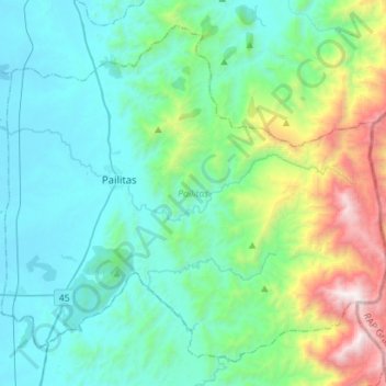
Name: Pailitas topographic map, elevation, terrain.

Location: Pailitas, Cesar, RAP Caribe, Colombia (8.82803 -73.70754 9.07021 -73.42622)

Average elevation: 259 m

Minimum elevation: 22 m

Maximum elevation: 1,680 m

Other topographic maps

Click on a map to view its topography, its elevation and its terrain.

Zapatosa

Colombia > Cesar > Tamalameque

Average elevation: 34 m

34

Colombia > Cesar > Perímetro Urbano Valledupar

Average elevation: 162 m

30

Colombia > Cesar > Perímetro Urbano Valledupar

Average elevation: 164 m

9

Colombia > Cesar > Perímetro Urbano Valledupar

Average elevation: 165 m

16

Colombia > Cesar > Perímetro Urbano Valledupar

Average elevation: 164 m

31

Colombia > Cesar > Perímetro Urbano Valledupar

Average elevation: 168 m

33

Colombia > Cesar > Perímetro Urbano Valledupar

Average elevation: 163 m

Gear up for your next adventure:

🔭Compact Binoculars - Lightweight optics for scouting trails and wildlife
🧥Thermal Fleece Jacket - Versatile insulation for changing mountain temperatures
💡Portable Camping Lamp - Rechargeable lamp for campsite lighting
🧦Outdoor Socks - Durable socks designed for hiking and outdoor sports
👟Leg Gaiters - Keep debris, mud, and snow out of your boots

As an Amazon Associate, this site earns from qualifying purchases at no extra cost to you.