
Make a donation
Gear up for your next adventure:
As an Amazon Associate, this site earns from qualifying purchases at no extra cost to you.
Piešťany topographic map
Click on the map to display elevation.
Make a donation
Gear up for your next adventure:
As an Amazon Associate, this site earns from qualifying purchases at no extra cost to you.
Piešťany
Piešťany is situated in the western part of Slovakia, in the valley of the Váh river, at an elevation of 162 metres (531.50 feet). The Považský Inovec mountains form the eastern boundary of this part of the Váh valley. The highest hill of these mountains, Inovec 1,042 m (3,418.64 ft), is about 25 km (16 mi) north of the town. The hills immediately east of the town (10 km (6 mi) away) reach a height of about 700 m (2,296.59 ft). On the western side, the valley boundary is formed by the Little Carpathians, which are somewhat lower and further away from the town. The valley is open to the south, and thus has a warm and sunny temperate climate.
Make a donation
Gear up for your next adventure:
As an Amazon Associate, this site earns from qualifying purchases at no extra cost to you.
About this map
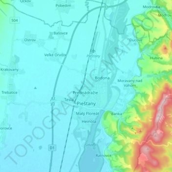
Name: Piešťany topographic map, elevation, terrain.
Average elevation: 196 m
Minimum elevation: 152 m
Maximum elevation: 473 m
Make a donation
Gear up for your next adventure:
As an Amazon Associate, this site earns from qualifying purchases at no extra cost to you.
Other topographic maps
Click on a map to view its topography, its elevation and its terrain.
Pod Holým vrchom
Slovakia > Region of Trnava > District of Piešťany > Dolný Lopašov
Average elevation: 256 m