
Thank you for supporting this site ❤️
Make a donation
Make a donation
Gear up for your next adventure:
As an Amazon Associate, this site earns from qualifying purchases at no extra cost to you.
Purullena topographic map
Click on the map to display elevation.
Thank you for supporting this site ❤️
Make a donation
Make a donation
Gear up for your next adventure:
As an Amazon Associate, this site earns from qualifying purchases at no extra cost to you.
About this map
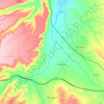
Name: Purullena topographic map, elevation, terrain.
Location: Purullena, Comarca de Guadix, Granada, Andalusia, 18519, Spain (37.31020 -3.24859 37.38477 -3.16953)
Average elevation: 900 m
Minimum elevation: 793 m
Maximum elevation: 1,037 m
Thank you for supporting this site ❤️
Make a donation
Make a donation
Gear up for your next adventure:
As an Amazon Associate, this site earns from qualifying purchases at no extra cost to you.