
Make a donation
Gear up for your next adventure:
As an Amazon Associate, this site earns from qualifying purchases at no extra cost to you.
Rikubetsu topographic map
Click on the map to display elevation.
Make a donation
Gear up for your next adventure:
As an Amazon Associate, this site earns from qualifying purchases at no extra cost to you.
Rikubetsu
Rikubetsu is located in southeastern Hokkaido in the northeastern part of the Tokachi Subprefecture. Rikubetsu is divided into two topographical zones by the Tobetsu River, which flows north-south through the center of the region. The western part is a highland plateau and is a center of dairy farming, while the eastern part is a plateau area with an elevation of approximately 500 meters. The town is located between 143°57' and 143°27' east longitude and 43°38' and 43°20' north latitude. The town hall is located at 143°45'8" east longitude and 43°28'1" north latitude, with an elevation of 205.8 meters. Mount Kitoushi at 1,321 meters is the highest point in town.
Make a donation
Gear up for your next adventure:
As an Amazon Associate, this site earns from qualifying purchases at no extra cost to you.
About this map
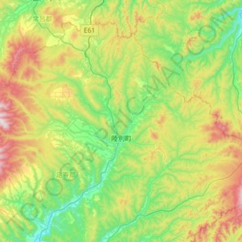
Name: Rikubetsu topographic map, elevation, terrain.
Average elevation: 398 m
Minimum elevation: 114 m
Maximum elevation: 1,046 m
Make a donation
Gear up for your next adventure:
As an Amazon Associate, this site earns from qualifying purchases at no extra cost to you.