Geolocate

Spiddal topographic map

Click on the map to display elevation.

About this map

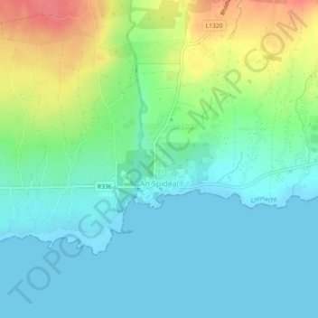
Name: Spiddal topographic map, elevation, terrain.

Location: Spiddal, County Galway, Connacht, Ireland (53.24183 -9.30886 53.25098 -9.29804)

Average elevation: 19 m

Minimum elevation: -2 m

Maximum elevation: 64 m

Other topographic maps

Click on a map to view its topography, its elevation and its terrain.

Cleggan

Ireland > County Galway

Average elevation: 29 m

Lough Loung

Ireland > County Galway

Average elevation: 65 m

Aughrim

Ireland > County Galway

Average elevation: 68 m

Gear up for your next adventure:

🩹Compact First Aid Kit - Pre-packed essentials for common trail injuries
🧤Rechargeable Heated Gloves - Extreme warmth for Canadian winter expeditions
🧢Outdoor Cap - Protective cap for sun and rain during hikes
🔭Compact Binoculars - Lightweight optics for scouting trails and wildlife
🔋Solar Power Bank - Keep your GPS and devices charged during long outdoor trips

As an Amazon Associate, this site earns from qualifying purchases at no extra cost to you.