Geolocate

Sherbourne topographic map

Click on the map to display elevation.

About this map

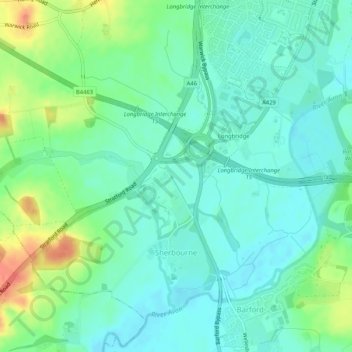
Name: Sherbourne topographic map, elevation, terrain.

Location: Sherbourne, Warwick, Warwickshire, England, United Kingdom (52.24441 -1.64776 52.27040 -1.59595)

Average elevation: 56 m

Minimum elevation: 41 m

Maximum elevation: 92 m

Other topographic maps

Click on a map to view its topography, its elevation and its terrain.

Leek Wootton

United Kingdom > England > Warwickshire > Warwick

Average elevation: 76 m

Gear up for your next adventure:

🧦Merino Wool Socks - Moisture-wicking comfort for long-distance hiking
👟Trail Running Shoes - Agile footwear for fast-paced topographic exploration
🧰Multitool Knife - Compact and versatile tool for outdoor use
🧭GPS Tracker - Track your location in remote areas safely
🔭Compact Monocular - One-handed bird watching and trail spotting

As an Amazon Associate, this site earns from qualifying purchases at no extra cost to you.