
Thank you for supporting this site ❤️
Make a donation
Make a donation
Gear up for your next adventure:
As an Amazon Associate, this site earns from qualifying purchases at no extra cost to you.
Edirne topographic map
Click on the map to display elevation.
Thank you for supporting this site ❤️
Make a donation
Make a donation
Gear up for your next adventure:
As an Amazon Associate, this site earns from qualifying purchases at no extra cost to you.
About this map
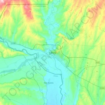
Name: Edirne topographic map, elevation, terrain.
Location: Edirne, Edirne Merkez, Edirne, Marmara Region, 22020, Turkey (41.51593 26.39872 41.83593 26.71872)
Average elevation: 92 m
Minimum elevation: 26 m
Maximum elevation: 316 m
Thank you for supporting this site ❤️
Make a donation
Make a donation
Gear up for your next adventure:
As an Amazon Associate, this site earns from qualifying purchases at no extra cost to you.