Geolocate

Odense topographic map

Click on the map to display elevation.

About this map
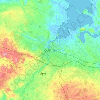
Name: Odense topographic map, elevation, terrain.

Location: Odense, Odense Municipality, Region of Southern Denmark, 5000, Denmark (55.23972 10.22521 55.55972 10.54521)

Average elevation: 30 m

Minimum elevation: -6 m

Maximum elevation: 122 m

Other topographic maps

Click on a map to view its topography, its elevation and its terrain.

Funen

Denmark > Region of Southern Denmark

Average elevation: 19 m

Funen

Denmark > Region of Southern Denmark

Average elevation: 19 m

Funen

Denmark > Region of Southern Denmark

Average elevation: 19 m

Funen

Denmark > Region of Southern Denmark

Average elevation: 19 m

Rømø

Denmark > Region of Southern Denmark

Average elevation: 0 m

Skarø

Denmark > Region of Southern Denmark

Average elevation: 0 m

Guldbjerg

Denmark > Region of Southern Denmark

Average elevation: 23 m

Egholm

Denmark > Region of Southern Denmark

Average elevation: 0 m

Funen

Denmark > Region of Southern Denmark

Average elevation: 19 m

Funen

Denmark > Region of Southern Denmark

Average elevation: 19 m

Ærø

Denmark > Region of Southern Denmark

Average elevation: 3 m

Gear up for your next adventure:

🪑Insulated Seat Pad - Protect your seat from cold rocks and wet logs
🧊Insulated Water Bottle - Keeps drinks cold in summer and prevents freezing in winter
🥾Hiking Shorts - Breathable shorts suitable for summer hikes
⛺Camping Essentials - All-in-one gear for a comfortable camping trip
⛺Camping Tent - Weather-resistant tents suitable for 2 to 6 people

As an Amazon Associate, this site earns from qualifying purchases at no extra cost to you.