Geolocate

Syleham topographic map

Click on the map to display elevation.

About this map

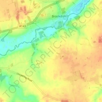
Name: Syleham topographic map, elevation, terrain.

Location: Syleham, Mid Suffolk, Suffolk, England, United Kingdom (52.34293 1.21687 52.37102 1.27906)

Average elevation: 40 m

Minimum elevation: 17 m

Maximum elevation: 56 m

Other topographic maps

Click on a map to view its topography, its elevation and its terrain.

Denham Green

United Kingdom > England > Suffolk > Mid Suffolk

Average elevation: 47 m

Gear up for your next adventure:

🧴Sunscreen SPF - Broad-spectrum sunscreen for outdoor activities
👖Convertible Hiking Pants - Zip-off legs to adapt to changing weather conditions
🧴Waterproofing Spray - Restore the DWR coating on jackets and tents
🧥Packable Rain Jacket - Breathable waterproof layer for unpredictable weather
🥾Waterproof Hiking Boots - Essential footwear for rugged terrain and wet Canadian trails

As an Amazon Associate, this site earns from qualifying purchases at no extra cost to you.