
Make a donation
Gear up for your next adventure:
As an Amazon Associate, this site earns from qualifying purchases at no extra cost to you.
Fez topographic map
Click on the map to display elevation.
Make a donation
Gear up for your next adventure:
As an Amazon Associate, this site earns from qualifying purchases at no extra cost to you.
Fez
The last major change to Fez's topography before the 20th century was made during the reign of Moulay Hassan I (1873–1894), who finally connected Fes Jdid and Fes el-Bali by building a walled corridor between them. New gardens and summer palaces, used by the royals and the capital's high society, were built within the corridor, such as the Jnan Sbil Gardens and the Dar Batha palace. Moulay Hassan also expanded the old Royal Palace itself, extending its entrance up to the current location of the Old Mechouar while adding the New Mechouar, along with the Dar al-Makina, to the north. The expansion separated the Moulay Abdallah neighbourhood to the northwest from the rest of Fes Jdid.
Make a donation
Gear up for your next adventure:
As an Amazon Associate, this site earns from qualifying purchases at no extra cost to you.
About this map
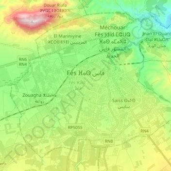
Name: Fez topographic map, elevation, terrain.
Average elevation: 432 m
Minimum elevation: 212 m
Maximum elevation: 832 m
Make a donation
Gear up for your next adventure:
As an Amazon Associate, this site earns from qualifying purchases at no extra cost to you.