Geolocate

Infernetto topographic map

Click on the map to display elevation.

About this map
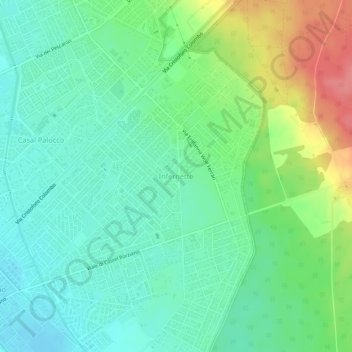
Name: Infernetto topographic map, elevation, terrain.

Location: Infernetto, Rome, Roma Capitale, Lazio, 00124, Italy (41.72519 12.35469 41.76519 12.39469)

Average elevation: 25 m

Minimum elevation: -2 m

Maximum elevation: 80 m

Other topographic maps

Click on a map to view its topography, its elevation and its terrain.
Villa Borghese Park

Italy > Lazio > Roma Capitale > Rome

Average elevation: 52 m

Villa Doria Pamphilj

Italy > Lazio > Roma Capitale > Rome

Average elevation: 67 m

Villa Celimontana

Italy > Lazio > Roma Capitale > Rome

Average elevation: 41 m

Tiber Island

Italy > Lazio > Roma Capitale > Rome

Average elevation: 38 m

Parco del Ninfeo

Italy > Lazio > Roma Capitale > Rome

Average elevation: 27 m

Gear up for your next adventure:

🔋Solar Power Bank - Keep your GPS and devices charged during long outdoor trips
💡Portable Camping Lamp - Rechargeable lamp for campsite lighting
🔦UV Flashlight - Detect minerals or specific insects in the dark
🥾Trail Hiking Boots - Supportive boots for rough trails
🔦LED Flashlight - Powerful and long-lasting flashlight for camping and emergencies

As an Amazon Associate, this site earns from qualifying purchases at no extra cost to you.