
Thank you for supporting this site ❤️
Make a donation
Make a donation
Gear up for your next adventure:
As an Amazon Associate, this site earns from qualifying purchases at no extra cost to you.
Cölbe topographic map
Click on the map to display elevation.
Thank you for supporting this site ❤️
Make a donation
Make a donation
Gear up for your next adventure:
As an Amazon Associate, this site earns from qualifying purchases at no extra cost to you.
About this map
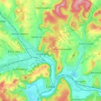
Name: Cölbe topographic map, elevation, terrain.
Location: Cölbe, Landkreis Marburg-Biedenkopf, Hesse, 35091, Germany (50.84012 8.74748 50.91333 8.87045)
Average elevation: 245 m
Minimum elevation: 180 m
Maximum elevation: 382 m
Thank you for supporting this site ❤️
Make a donation
Make a donation
Gear up for your next adventure:
As an Amazon Associate, this site earns from qualifying purchases at no extra cost to you.