Geolocate

Evanston topographic map

Click on the map to display elevation.

About this map
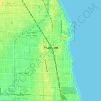
Name: Evanston topographic map, elevation, terrain.

Location: Evanston, Evanston Township, Cook County, Illinois, United States (42.01915 -87.73246 42.07177 -87.66502)

Average elevation: 184 m

Minimum elevation: 175 m

Maximum elevation: 198 m

Other topographic maps

Click on a map to view its topography, its elevation and its terrain.
Symphony Lake

United States > Illinois > Cook County > Chicago

Average elevation: 181 m

Gear up for your next adventure:

🚲Bike Repair Kit - Essential tools for on-trail mechanical issues
📷Outdoor Action Camera - Capture high-elevation views and rugged adventures
🔋Lithium AA Batteries - Long-lasting power that performs in extreme cold
🥾Hiking Shoes - Durable and comfortable shoes for trail hiking
🧥Ultralight Puffy Jacket - Maximum warmth that packs down to the size of an orange

As an Amazon Associate, this site earns from qualifying purchases at no extra cost to you.