Geolocate

Borgomanero topographic map

Click on the map to display elevation.

About this map

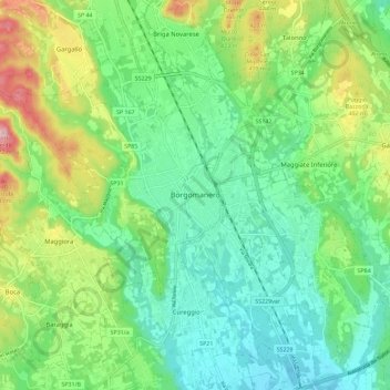
Name: Borgomanero topographic map, elevation, terrain.

Location: Borgomanero, Novara, Piedmont, 28021, Italy (45.65990 8.40408 45.73761 8.51853)

Average elevation: 341 m

Minimum elevation: 271 m

Maximum elevation: 500 m

Other topographic maps

Click on a map to view its topography, its elevation and its terrain.

Agrate

Italy > Piedmont > Novara

Average elevation: 324 m

Pisogno

Italy > Piedmont > Novara > Miasino

Average elevation: 527 m

Gaggiolo

Italy > Piedmont > Novara

Average elevation: 211 m

Gear up for your next adventure:

🛰️Satellite Messenger - Emergency communication for areas with no cell service
Camping Coffee Maker - Brew fresh coffee anywhere on the topographic map
🧳Compression Sacks - Maximize space in your backpack by shrinking gear
Family Camping Tent - Spacious tent suitable for family camping trips
🍽️Titanium Camping Spork - Ultralight and indestructible eating utensil

As an Amazon Associate, this site earns from qualifying purchases at no extra cost to you.