
Make a donation
Gear up for your next adventure:
As an Amazon Associate, this site earns from qualifying purchases at no extra cost to you.
Anku topographic map
Click on the map to display elevation.
Make a donation
Gear up for your next adventure:
As an Amazon Associate, this site earns from qualifying purchases at no extra cost to you.
About this map
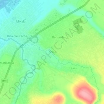
Name: Anku topographic map, elevation, terrain.
Location: Anku, Nsele, Kinshasa, Democratic Republic of the Congo (-4.35424 15.50836 -4.31424 15.54836)
Average elevation: 307 m
Minimum elevation: 266 m
Maximum elevation: 382 m
Make a donation
Gear up for your next adventure:
As an Amazon Associate, this site earns from qualifying purchases at no extra cost to you.
Other topographic maps
Click on a map to view its topography, its elevation and its terrain.
Make a donation
Gear up for your next adventure:
As an Amazon Associate, this site earns from qualifying purchases at no extra cost to you.
N'djili
Democratic Republic of the Congo > Kinshasa
The river catchment has sandy soils and steep topography, as with other rivers that supply the city. With clearing of the forests, there has been growing soil erosion, leading to sediment pollution. When turbidity levels rise above the 1,000 NTU limit, which has often been reported in the Ndjili and Lukaya…
Average elevation: 362 m