Geolocate

Naivasha topographic map

Click on the map to display elevation.

About this map

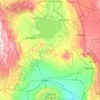
Name: Naivasha topographic map, elevation, terrain.

Location: Naivasha, Nakuru West, Nakuru, Rift Valley, 20117, Kenya (-1.15469 36.09913 -0.61555 36.59833)

Average elevation: 2,097 m

Minimum elevation: 1,512 m

Maximum elevation: 3,080 m

Other topographic maps

Click on a map to view its topography, its elevation and its terrain.

Kenya

Kenya > Nakuru > Nakuru East > Nakuru East ward

Average elevation: 1,831 m

Wild Fire

Kenya > Nakuru > Naivasha > Hells Gate ward > Junction 1

Average elevation: 1,952 m

Fire

Kenya > Nakuru

Average elevation: 1,832 m

Mai Maihu

Kenya > Nakuru

Average elevation: 1,868 m

Gear up for your next adventure:

🧴Outdoor Sunscreen - High SPF protection for high-altitude UV exposure
🎒Fully Waterproof Backpack - Total protection for photography gear and electronics
Camping Groundsheet - Protect your tent from moisture and dirt
Family Camping Tent - Spacious tent suitable for family camping trips
🧦Merino Wool Socks - Moisture-wicking comfort for long-distance hiking

As an Amazon Associate, this site earns from qualifying purchases at no extra cost to you.