Geolocate

Ungaran topographic map

Click on the map to display elevation.

About this map

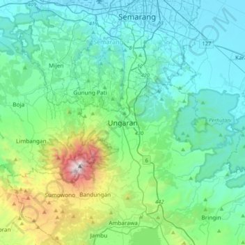
Name: Ungaran topographic map, elevation, terrain.

Location: Ungaran, Semarang, Central Java, Java, 50511, Indonesia (-7.28909 110.24389 -6.96909 110.56389)

Average elevation: 357 m

Minimum elevation: 0 m

Maximum elevation: 2,001 m

Gear up for your next adventure:

🧥Thermal Fleece Jacket - Versatile insulation for changing mountain temperatures
🕶️Polarized Sunglasses - Reduces glare from snow and water at high elevations
🔦UV Flashlight - Detect minerals or specific insects in the dark
🧼Travel Hand Sanitizer - Keep hands clean when water is scarce
🛶Kayak Dry Bag - Waterproof storage for kayaking adventures

As an Amazon Associate, this site earns from qualifying purchases at no extra cost to you.