Geolocate

Kingston topographic map

Click on the map to display elevation.

About this map
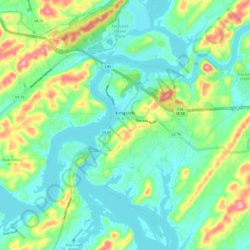
Name: Kingston topographic map, elevation, terrain.

Location: Kingston, Roane County, East Tennessee, Tennessee, United States (35.83773 -84.53332 35.89505 -84.41284)

Average elevation: 260 m

Minimum elevation: 221 m

Maximum elevation: 355 m

Other topographic maps

Click on a map to view its topography, its elevation and its terrain.
Pine Hills

United States > Tennessee > Roane County > Harriman

Average elevation: 278 m

Bazel Town

United States > Tennessee > Roane County > Harriman

Average elevation: 323 m

Clinch River

United States > Tennessee > Roane County > Kingston

Average elevation: 252 m

Scandlyn

United States > Tennessee > Roane County

Average elevation: 302 m

Blair

United States > Tennessee > Roane County

Average elevation: 314 m

Emory Gap

United States > Tennessee > Roane County > Harriman

Average elevation: 305 m

Bazel Town

United States > Tennessee > Roane County > Harriman

Average elevation: 323 m

Cave Creek

United States > Tennessee > Roane County

Average elevation: 308 m

Walnut Hill

United States > Tennessee > Roane County > Harriman

Average elevation: 279 m

Dogwood Shores

United States > Tennessee > Roane County

Average elevation: 251 m

Allingham

United States > Tennessee > Roane County

Average elevation: 262 m

Gear up for your next adventure:

🥘Camping Cookware Set - Compact nesting pots and pans for trail cooking
🧦Merino Wool Socks - Moisture-wicking comfort for long-distance hiking
🥾Light Hiking Boots - Lightweight and comfortable boots for day hikes
🧰Survival Kit - Essential gear for emergencies in the wilderness
🧥Thermal Layer - Insulating layer for cold outdoor conditions

As an Amazon Associate, this site earns from qualifying purchases at no extra cost to you.