Geolocate

Crested Butte topographic map

Click on the map to display elevation.

Crested Butte

At the 2020 United States Census, the town had a total area of 535 acres (2.166 km2), all of it land. Crested Butte lies at an elevation of 8,885 feet (2,708 m) above sea level.

Wikipedia (CC-BY-SA 3.0)

About this map

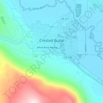
Name: Crested Butte topographic map, elevation, terrain.

Location: Crested Butte, Gunnison County, Colorado, 81224, United States (38.85882 -106.99228 38.87491 -106.96267)

Average elevation: 2,798 m

Minimum elevation: 2,693 m

Maximum elevation: 3,177 m

Gear up for your next adventure:

💡Solar Camping Lamp - Eco-friendly lighting for campsites
🔦LED Headtorch - Bright and durable light for night activities
🧭Orienteering Kit - Tools for map reading and navigation in the wild
🛁Quick-Dry Microfiber Towel - Space-saving towel that dries rapidly on the move
🧦Outdoor Socks - Durable socks designed for hiking and outdoor sports

As an Amazon Associate, this site earns from qualifying purchases at no extra cost to you.