Geolocate

Iona topographic map

Click on the map to display elevation.

About this map

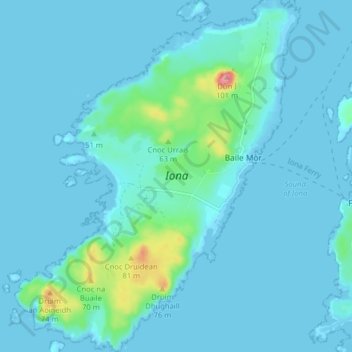
Name: Iona topographic map, elevation, terrain.

Location: Iona, The Village, Argyll and Bute, Scotland, United Kingdom (56.30670 -6.44491 56.35095 -6.38138)

Average elevation: 9 m

Minimum elevation: -1 m

Maximum elevation: 96 m

Gear up for your next adventure:

🦯Trekking Poles - Reduced impact on joints for steep topographic climbs
🔨Vehicle Emergency Tool - Safety tool for remote road trips to trailheads
🧴Outdoor Sunscreen - High SPF protection for high-altitude UV exposure
🎒Hiking Daypack - Lightweight and durable backpacks for day trips and excursions
🦶Hiking Shoe Insoles - Added support for high arches and long days on feet

As an Amazon Associate, this site earns from qualifying purchases at no extra cost to you.