
Thank you for supporting this site ❤️
Make a donation
Make a donation
Gear up for your next adventure:
As an Amazon Associate, this site earns from qualifying purchases at no extra cost to you.
Dübendorf topographic map
Click on the map to display elevation.
Thank you for supporting this site ❤️
Make a donation
Make a donation
Gear up for your next adventure:
As an Amazon Associate, this site earns from qualifying purchases at no extra cost to you.
About this map
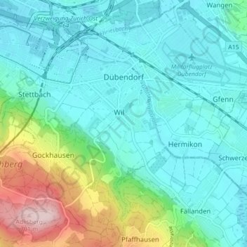
Name: Dübendorf topographic map, elevation, terrain.
Location: Dübendorf, Bezirk Uster, Zurich, 8600, Switzerland (47.36681 8.58305 47.40933 8.65287)
Average elevation: 487 m
Minimum elevation: 426 m
Maximum elevation: 707 m
Thank you for supporting this site ❤️
Make a donation
Make a donation
Gear up for your next adventure:
As an Amazon Associate, this site earns from qualifying purchases at no extra cost to you.