Geolocate

Saclay topographic map

Click on the map to display elevation.

About this map
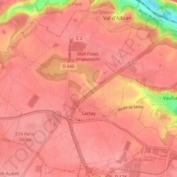
Name: Saclay topographic map, elevation, terrain.

Location: Saclay, Palaiseau, Essonne, Ile-de-France, Metropolitan France, 91400, France (48.71468 2.13508 48.75881 2.20368)

Average elevation: 148 m

Minimum elevation: 75 m

Maximum elevation: 165 m

Other topographic maps

Click on a map to view its topography, its elevation and its terrain.
Vauboyen

France > Ile-de-France > Essonne

Average elevation: 143 m

Gear up for your next adventure:

🛰️Satellite Messenger - Emergency communication for areas with no cell service
🪑Insulated Seat Pad - Protect your seat from cold rocks and wet logs
🦶Hiking Shoe Insoles - Added support for high arches and long days on feet
🥾Waterproof Hiking Boots - Essential footwear for rugged terrain and wet Canadian trails
🔭Compact Monocular - One-handed bird watching and trail spotting

As an Amazon Associate, this site earns from qualifying purchases at no extra cost to you.