Geolocate

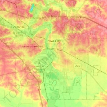
Iowa City topographic map

Click on the map to display elevation.

Iowa City

The elevation at the Iowa City Municipal Airport is 668 ft (204 m) above sea level.

Wikipedia (CC-BY-SA 3.0)

About this map

Name: Iowa City topographic map, elevation, terrain.

Location: Iowa City, Johnson County, Iowa, United States (41.59855 -91.61849 41.69663 -91.46306)

Average elevation: 216 m

Minimum elevation: 162 m

Maximum elevation: 254 m

Other topographic maps

Click on a map to view its topography, its elevation and its terrain.
Cosgrove

United States > Iowa > Johnson County

Average elevation: 228 m

Cosgrove

United States > Iowa > Johnson County

Average elevation: 228 m

Gear up for your next adventure:

🥾Light Trekking Boots - Supportive boots for multi-day treks
🩹Compact First Aid Kit - Pre-packed essentials for common trail injuries
🧦Hiking Socks - Moisture-wicking and comfortable socks for long hikes
🔭Compact Monocular - One-handed bird watching and trail spotting
🦟Insect Repellent - Keep mosquitoes and black flies away in wooded areas

As an Amazon Associate, this site earns from qualifying purchases at no extra cost to you.