
Make a donation
Gear up for your next adventure:
As an Amazon Associate, this site earns from qualifying purchases at no extra cost to you.
Guatemala City topographic map
Click on the map to display elevation.
Make a donation
Gear up for your next adventure:
As an Amazon Associate, this site earns from qualifying purchases at no extra cost to you.
Guatemala City
Despite its location in the tropics, Guatemala City has a monsoon humid subtropical climate (Köppen Cwa) due to its relatively high altitude which moderate the average temperatures. Guatemala City is generally very warm, almost springlike, throughout the course of the year.
Make a donation
Gear up for your next adventure:
As an Amazon Associate, this site earns from qualifying purchases at no extra cost to you.
About this map
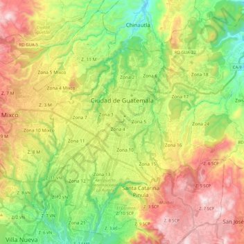
Name: Guatemala City topographic map, elevation, terrain.
Location: Guatemala City, Guatemala Department, Guatemala (14.53641 -90.58709 14.71379 -90.38541)
Average elevation: 1,531 m
Minimum elevation: 1,164 m
Maximum elevation: 2,017 m
Make a donation
Gear up for your next adventure:
As an Amazon Associate, this site earns from qualifying purchases at no extra cost to you.
Other topographic maps
Click on a map to view its topography, its elevation and its terrain.
Los Ruches
Guatemala > Guatemala Department > Chinautla > San Antonio las Flores
Average elevation: 1,256 m
Santa Catarina Pinula
Guatemala > Guatemala Department > Santa Catarina Pinula
Average elevation: 1,581 m
Make a donation
Gear up for your next adventure:
As an Amazon Associate, this site earns from qualifying purchases at no extra cost to you.
Colonia Villa de San Juan
Guatemala > Guatemala Department > Guatemala City
Average elevation: 1,535 m
Make a donation
Gear up for your next adventure:
As an Amazon Associate, this site earns from qualifying purchases at no extra cost to you.