Geolocate

Carol Stream topographic map

Click on the map to display elevation.

About this map

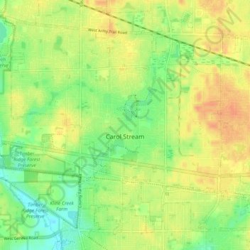
Name: Carol Stream topographic map, elevation, terrain.

Location: Carol Stream, DuPage County, Illinois, 60188, United States (41.88803 -88.17486 41.94281 -88.08717)

Average elevation: 236 m

Minimum elevation: 217 m

Maximum elevation: 251 m

Gear up for your next adventure:

🚲Handlebar Phone Mount - View topographic-map.com live while cycling
🥾Trail Hiking Boots - Supportive boots for rough trails
Tent Footprint - Protect tent floor and increase durability
🔦UV Flashlight - Detect minerals or specific insects in the dark
🥾Light Trekking Boots - Supportive boots for multi-day treks

As an Amazon Associate, this site earns from qualifying purchases at no extra cost to you.