
Thank you for supporting this site ❤️
Make a donation
Make a donation
Gear up for your next adventure:
As an Amazon Associate, this site earns from qualifying purchases at no extra cost to you.
Chequerec topographic map
Click on the map to display elevation.
Thank you for supporting this site ❤️
Make a donation
Make a donation
Gear up for your next adventure:
As an Amazon Associate, this site earns from qualifying purchases at no extra cost to you.
About this map
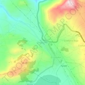
Name: Chequerec topographic map, elevation, terrain.
Location: Chequerec, Maras, Province of Urubamba, Cusco, Peru (-13.39675 -72.14333 -13.35675 -72.10333)
Average elevation: 3,603 m
Minimum elevation: 3,431 m
Maximum elevation: 3,880 m
Thank you for supporting this site ❤️
Make a donation
Make a donation
Gear up for your next adventure:
As an Amazon Associate, this site earns from qualifying purchases at no extra cost to you.