Geolocate

Bleckenau topographic map

Click on the map to display elevation.

About this map

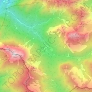
Name: Bleckenau topographic map, elevation, terrain.

Location: Bleckenau, Schwangau, Landkreis Ostallgäu, Bavaria, Germany (47.51866 10.75527 47.55866 10.79527)

Average elevation: 1,435 m

Minimum elevation: 828 m

Maximum elevation: 2,019 m

Other topographic maps

Click on a map to view its topography, its elevation and its terrain.

Forggensee

Germany > Bavaria > Landkreis Ostallgäu > Schwangau

Average elevation: 821 m

Gear up for your next adventure:

🥾Hiking Shorts - Breathable shorts suitable for summer hikes
🥾Hiking Gaiters - Protect legs and shoes from mud, snow, and debris
🧢Sun Protection Cap - Breathable cap to protect from sun exposure
🧢Outdoor Cap - Protective cap for sun and rain during hikes
Lightweight Backpacking Tent - Compact tent for efficient hiking trips

As an Amazon Associate, this site earns from qualifying purchases at no extra cost to you.