Geolocate

Pahoa CDP topographic map

Click on the map to display elevation.

About this map

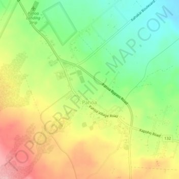
Name: Pahoa CDP topographic map, elevation, terrain.

Location: Pahoa CDP, Hawaiʻi County, Hawaii, United States (19.48307 -154.96471 19.51574 -154.92510)

Average elevation: 192 m

Minimum elevation: 122 m

Maximum elevation: 273 m

Other topographic maps

Click on a map to view its topography, its elevation and its terrain.

Waikoloa

United States > Hawaii > Hawaiʻi County

Average elevation: 271 m

Gear up for your next adventure:

🪑Insulated Seat Pad - Protect your seat from cold rocks and wet logs
🔭Outdoor Binoculars - Lightweight binoculars for birdwatching and hiking
🧴Sunscreen SPF - Broad-spectrum sunscreen for outdoor activities
🎒Fully Waterproof Backpack - Total protection for photography gear and electronics
🧢Hiking Hat - Sun-protective and breathable hats for long treks

As an Amazon Associate, this site earns from qualifying purchases at no extra cost to you.