Geolocate

Erding topographic map

Click on the map to display elevation.

About this map

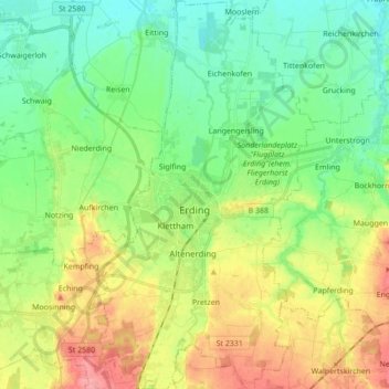
Name: Erding topographic map, elevation, terrain.

Location: Erding, Landkreis Erding, Bavaria, 85435, Germany (48.25331 11.86084 48.36812 11.96101)

Average elevation: 465 m

Minimum elevation: 434 m

Maximum elevation: 519 m

Gear up for your next adventure:

💧Hydration Pack - Hands-free hydration system for long hikes
🔪Outdoor Multitool - Versatile tool for repairs and food prep in the wild
🧢Sun Hat - Wide-brim hat for sun protection
🧥Softshell Jacket - Windproof and breathable jacket for hiking
🦯Trekking Poles - Reduced impact on joints for steep topographic climbs

As an Amazon Associate, this site earns from qualifying purchases at no extra cost to you.