Geolocate

Santpedor topographic map

Click on the map to display elevation.

About this map

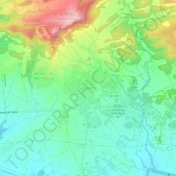
Name: Santpedor topographic map, elevation, terrain.

Location: Santpedor, Bages, Barcelona, Catalonia, 08251, Spain (41.76476 1.81869 41.80476 1.85869)

Average elevation: 335 m

Minimum elevation: 263 m

Maximum elevation: 486 m

Gear up for your next adventure:

🔥Camping Stove - Portable stoves to cook outdoors with ease
🥾Trail Running Boots - Durable shoes designed for trail running
🔦UV Flashlight - Detect minerals or specific insects in the dark
🧦Hiking Socks - Moisture-wicking and comfortable socks for long hikes
🔭Outdoor Binoculars - Lightweight binoculars for birdwatching and hiking

As an Amazon Associate, this site earns from qualifying purchases at no extra cost to you.