
Mansfield topographic map
Click on the map to display elevation.
Mansfield
Mansfield is located at 40°45′17″N 82°31′22″W / 40.75472°N 82.52278°W / 40.75472; -82.52278 (40.754856, −82.522855), directly between Columbus and Cleveland, however, the city lies in the western foothills of the Allegheny Plateau, and its elevation is among the highest of Ohio cities. The highest point in the city 1,493 feet (455 m) above sea level is located at the Woodland Reservoir, an underground water storage (service reservoir) along Woodland Road in southwest Mansfield. The elevation in downtown Mansfield, which is located at Central Park is 1,240 feet (378 m) above sea level, and at Mansfield Lahm Airport, the elevation is 1,293 feet (394 m) above sea level. The highest point in Richland County, second highest point in Ohio (after Campbell Hill) is between 1,510 feet (460 m) and 1,520 feet (463 m) above sea level is located southwest of the city, just off Lexington-Ontario Road at Apple Hill Orchards in Springfield Township.
About this map
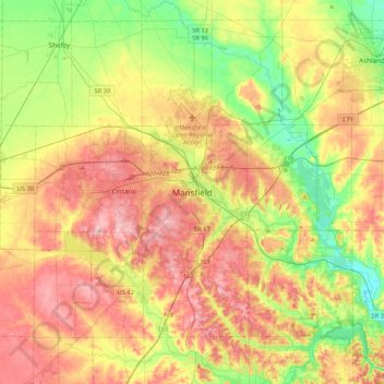
Name: Mansfield topographic map, elevation, terrain.
Location: Mansfield, Richland County, Ohio, 44902, United States (40.59839 -82.67545 40.91839 -82.35545)
Average elevation: 371 m
Minimum elevation: 290 m
Maximum elevation: 462 m