
Thank you for supporting this site ❤️
Make a donation
Make a donation
Gear up for your next adventure:
As an Amazon Associate, this site earns from qualifying purchases at no extra cost to you.
Figari/Golfo Aranci topographic map
Click on the map to display elevation.
Thank you for supporting this site ❤️
Make a donation
Make a donation
Gear up for your next adventure:
As an Amazon Associate, this site earns from qualifying purchases at no extra cost to you.
About this map
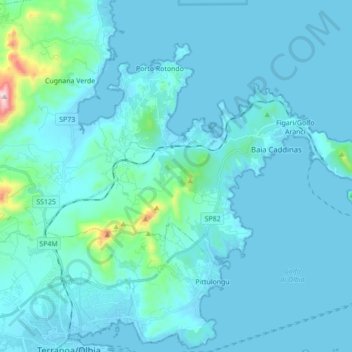
Name: Figari/Golfo Aranci topographic map, elevation, terrain.
Location: Figari/Golfo Aranci, Sassari, Sardinia, Italy (40.95365 9.49093 41.02266 9.66457)
Average elevation: 17 m
Minimum elevation: -2 m
Maximum elevation: 388 m
Thank you for supporting this site ❤️
Make a donation
Make a donation
Gear up for your next adventure:
As an Amazon Associate, this site earns from qualifying purchases at no extra cost to you.
Other topographic maps
Click on a map to view its topography, its elevation and its terrain.