Geolocate

Grad Gospić topographic map

Click on the map to display elevation.

About this map

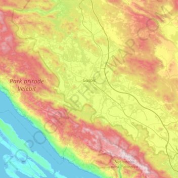
Name: Grad Gospić topographic map, elevation, terrain.

Location: Grad Gospić, Lika-Senj County, Croatia (44.33952 15.06300 44.70971 15.65121)

Average elevation: 668 m

Minimum elevation: -4 m

Maximum elevation: 1,751 m

Gear up for your next adventure:

🥾Trekking Boots - Durable boots for long-distance trekking
🧰Survival Kit - Essential gear for emergencies in the wilderness
🧴Outdoor Sunscreen - High SPF protection for high-altitude UV exposure
🧦Outdoor Socks - Durable socks designed for hiking and outdoor sports
🚲Bike Repair Kit - Essential tools for on-trail mechanical issues

As an Amazon Associate, this site earns from qualifying purchases at no extra cost to you.