Geolocate

Flädie topographic map

Click on the map to display elevation.

About this map

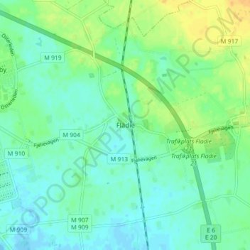
Name: Flädie topographic map, elevation, terrain.

Location: Flädie, Lomma kommun, Skåne County, 237 91, Sweden (55.70527 13.05198 55.74527 13.09198)

Average elevation: 9 m

Minimum elevation: -3 m

Maximum elevation: 25 m

Other topographic maps

Click on a map to view its topography, its elevation and its terrain.

Vellinge kommun

Sweden > Skåne County

Average elevation: 8 m

Klippans kommun

Sweden > Skåne County

Average elevation: 75 m

Ystads kommun

Sweden > Skåne County

Average elevation: 22 m

Båstads kommun

Sweden > Skåne County

Average elevation: 36 m

Gear up for your next adventure:

🔥Emergency Fire Starter - Reliable ignition source for all weather conditions
🧥Fleece Jacket - Warm and lightweight jacket for layering
🧦Outdoor Socks - Durable socks designed for hiking and outdoor sports
🔪Outdoor Multitool - Versatile tool for repairs and food prep in the wild
👟Sport Hiking Sandals - Breathable footwear for water crossings and camp rest

As an Amazon Associate, this site earns from qualifying purchases at no extra cost to you.