Geolocate

Beilngries topographic map

Click on the map to display elevation.

About this map
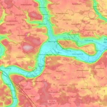
Name: Beilngries topographic map, elevation, terrain.

Location: Beilngries, Landkreis Eichstätt, Bavaria, 92339, Germany (48.95162 11.38549 49.08770 11.59514)

Average elevation: 480 m

Minimum elevation: 357 m

Maximum elevation: 575 m

Other topographic maps

Click on a map to view its topography, its elevation and its terrain.

Schamhaupten

Germany > Bavaria > Landkreis Eichstätt

Average elevation: 460 m

Gungolding

Germany > Bavaria > Landkreis Eichstätt

Average elevation: 441 m

Preith

Germany > Bavaria > Landkreis Eichstätt

Average elevation: 531 m

Gear up for your next adventure:

🧢Hiking Hat - Sun-protective and breathable hats for long treks
🔥Camping Stove - Portable stoves to cook outdoors with ease
🚑Survival Whistle - Signal for help across long distances in mountains
🥾Hiking Gaiters - Protect legs and shoes from mud, snow, and debris
🧥Ultralight Puffy Jacket - Maximum warmth that packs down to the size of an orange

As an Amazon Associate, this site earns from qualifying purchases at no extra cost to you.