
Make a donation
Gear up for your next adventure:
As an Amazon Associate, this site earns from qualifying purchases at no extra cost to you.
Baie-Comeau topographic map
Click on the map to display elevation.
Make a donation
Gear up for your next adventure:
As an Amazon Associate, this site earns from qualifying purchases at no extra cost to you.
About this map
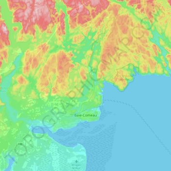
Name: Baie-Comeau topographic map, elevation, terrain.
Location: Baie-Comeau, Manicouagan, Côte-Nord, Quebec, Canada (49.17954 -68.50306 49.34707 -68.04533)
Average elevation: 104 m
Minimum elevation: -1 m
Maximum elevation: 409 m
Manicouagan trails, hiking, mountain biking, running and outdoor activities
Make a donation
Gear up for your next adventure:
As an Amazon Associate, this site earns from qualifying purchases at no extra cost to you.
Other topographic maps
Click on a map to view its topography, its elevation and its terrain.
Make a donation
Gear up for your next adventure:
As an Amazon Associate, this site earns from qualifying purchases at no extra cost to you.