Geolocate

Coswig topographic map

Click on the map to display elevation.

About this map

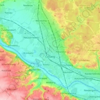
Name: Coswig topographic map, elevation, terrain.

Location: Coswig, Meißen, Saxony, 01640, Germany (51.10479 13.49942 51.16146 13.65542)

Average elevation: 156 m

Minimum elevation: 94 m

Maximum elevation: 270 m

Gear up for your next adventure:

🧴Sunscreen SPF - Broad-spectrum sunscreen for outdoor activities
🥾Light Hiking Boots - Lightweight and comfortable boots for day hikes
🗺️Topographic Maps - Detailed maps to explore trails, mountains, and wilderness areas
🧼Biodegradable Camp Soap - Environmentally friendly cleaning for gear and body
🛁Quick-Dry Microfiber Towel - Space-saving towel that dries rapidly on the move

As an Amazon Associate, this site earns from qualifying purchases at no extra cost to you.