
Make a donation
Gear up for your next adventure:
As an Amazon Associate, this site earns from qualifying purchases at no extra cost to you.
Bad Honnef topographic map
Click on the map to display elevation.
Make a donation
Gear up for your next adventure:
As an Amazon Associate, this site earns from qualifying purchases at no extra cost to you.
About this map
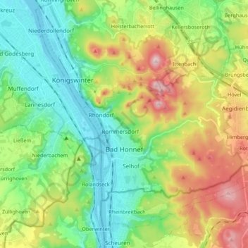
Name: Bad Honnef topographic map, elevation, terrain.
Average elevation: 182 m
Minimum elevation: 51 m
Maximum elevation: 436 m
Make a donation
Gear up for your next adventure:
As an Amazon Associate, this site earns from qualifying purchases at no extra cost to you.
Other topographic maps
Click on a map to view its topography, its elevation and its terrain.
Breitscheid
Germany > North Rhine-Westphalia > Rhein-Sieg-Kreis > Neunkirchen-Seelscheid
Average elevation: 179 m
Make a donation
Gear up for your next adventure:
As an Amazon Associate, this site earns from qualifying purchases at no extra cost to you.
Pinn
Germany > North Rhine-Westphalia > Rhein-Sieg-Kreis > Neunkirchen-Seelscheid > Remschoß
Average elevation: 169 m
Make a donation
Gear up for your next adventure:
As an Amazon Associate, this site earns from qualifying purchases at no extra cost to you.
Niederhalberg
Germany > North Rhine-Westphalia > Rhein-Sieg-Kreis > Hennef (Sieg) > Niederhalberg
Average elevation: 144 m
Uthweiler
Germany > North Rhine-Westphalia > Rhein-Sieg-Kreis > Königswinter > Uthweiler
Average elevation: 157 m
Heisterbacherrott
Germany > North Rhine-Westphalia > Rhein-Sieg-Kreis > Königswinter
Average elevation: 211 m