Geolocate

Pataias topographic map

Click on the map to display elevation.

About this map

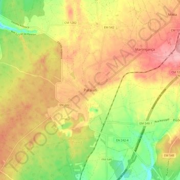
Name: Pataias topographic map, elevation, terrain.

Location: Pataias, Alcobaça, Leiria, 2445-267, Portugal (39.63072 -9.03290 39.71072 -8.95290)

Average elevation: 104 m

Minimum elevation: 30 m

Maximum elevation: 165 m

Other topographic maps

Click on a map to view its topography, its elevation and its terrain.

São Martinho do Porto

Portugal > Leiria > Alcobaça

Average elevation: 19 m

Pataias

Portugal > Leiria > Alcobaça

Average elevation: 72 m

Gear up for your next adventure:

🌬️Windproof Camp Stove - Efficient cooking even on exposed mountain peaks
🧊Portable Cooler - Keep food and drinks cold during outdoor adventures
🥾Waterproof Hiking Boots - Essential footwear for rugged terrain and wet Canadian trails
Lightweight Backpacking Tent - Compact tent for efficient hiking trips
🔦UV Flashlight - Detect minerals or specific insects in the dark

As an Amazon Associate, this site earns from qualifying purchases at no extra cost to you.