Geolocate

Eynsford topographic map

Click on the map to display elevation.

About this map

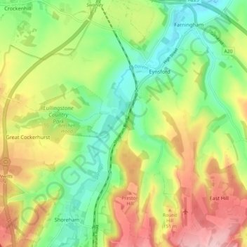
Name: Eynsford topographic map, elevation, terrain.

Location: Eynsford, Sevenoaks, Kent, England, United Kingdom (51.32744 0.15760 51.38397 0.23640)

Average elevation: 104 m

Minimum elevation: 30 m

Maximum elevation: 204 m

Gear up for your next adventure:

👟Sport Hiking Sandals - Breathable footwear for water crossings and camp rest
🧴Outdoor Sunscreen - High SPF protection for high-altitude UV exposure
🥾Trail Running Boots - Durable shoes designed for trail running
Lightweight Backpacking Tent - Compact tent for efficient hiking trips
Family Camping Tent - Spacious tent suitable for family camping trips

As an Amazon Associate, this site earns from qualifying purchases at no extra cost to you.