
Helgoland topographic map
Click on the map to display elevation.
About this map
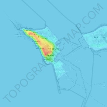
Name: Helgoland topographic map, elevation, terrain.
Location: Helgoland, Kreis Pinneberg, Schleswig-Holstein, 27498, Germany (54.16931 7.86484 54.19172 7.92143)
Average elevation: 1 m
Minimum elevation: 0 m
Maximum elevation: 54 m
Other topographic maps
Click on a map to view its topography, its elevation and its terrain.
Heligoland
Germany > Schleswig-Holstein > Kreis Pinneberg > Helgoland > Helgoland
Average elevation: 2 m