Geolocate

2nd district topographic map

Click on the map to display elevation.

About this map

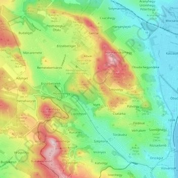
Name: 2nd district topographic map, elevation, terrain.

Location: 2nd district, Budapest, Central Hungary, Hungary (47.50607 18.92511 47.57891 19.04271)

Average elevation: 252 m

Minimum elevation: 100 m

Maximum elevation: 513 m

Gear up for your next adventure:

🧴Insect Repellent - Protect yourself from bugs during outdoor adventures
🧤Thermal Hiking Gloves - Grip-enhanced gloves for cold-weather altitude trekking
🥾Light Trekking Boots - Supportive boots for multi-day treks
🛏️Sleeping Bag - Warm and compact sleeping bags for outdoor camping
🧭Orienteering Kit - Tools for map reading and navigation in the wild

As an Amazon Associate, this site earns from qualifying purchases at no extra cost to you.