Geolocate

Happy Camp topographic map

Click on the map to display elevation.

About this map

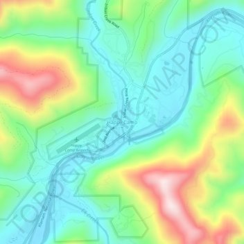
Name: Happy Camp topographic map, elevation, terrain.

Location: Happy Camp, Siskiyou County, CAL Fire Northern Region, California, United States (41.77319 -123.39920 41.81319 -123.35920)

Average elevation: 470 m

Minimum elevation: 314 m

Maximum elevation: 801 m

Other topographic maps

Click on a map to view its topography, its elevation and its terrain.

Hornbrook

United States > California > Siskiyou County

Average elevation: 704 m

Gear up for your next adventure:

💡LED Headlamp - Hands-free illumination for night hiking and camping
🔭Compact Monocular - One-handed bird watching and trail spotting
🌡️Emergency Mylar Blankets - Compact thermal protection for unexpected nights outdoors
🥾Trail Running Shoes - Lightweight and durable shoes for trail running
🧳Compression Sacks - Maximize space in your backpack by shrinking gear

As an Amazon Associate, this site earns from qualifying purchases at no extra cost to you.