Geolocate

Hollins topographic map

Click on the map to display elevation.

About this map

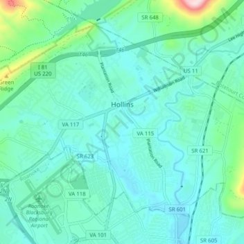
Name: Hollins topographic map, elevation, terrain.

Location: Hollins, Roanoke County, Virginia, United States (37.31992 -79.99778 37.36751 -79.92046)

Average elevation: 359 m

Minimum elevation: 294 m

Maximum elevation: 688 m

Gear up for your next adventure:

🦯Trekking Poles - Reduced impact on joints for steep topographic climbs
💧Hydration Bladder - Hands-free hydration solution for long treks
🥾Trail Hiking Socks - Comfortable socks to prevent blisters and fatigue
💡Compact LED Flashlight - Powerful and portable flashlight for outdoor use
🔦LED Headtorch - Bright and durable light for night activities

As an Amazon Associate, this site earns from qualifying purchases at no extra cost to you.