
Loxahatchee Groves topographic map
Click on the map to display elevation.
Loxahatchee Groves
The area now known as Loxahatchee Groves was originally a portion of the 2,000,000 acres (8,100 km2) of land purchased by the Southern States Land and Timber Company in 1902. After the West Palm Beach Canal (C-51), which connected Lake Okeechobee at Canal Point to West Palm Beach, was completed in 1917, George Frederick Bensel, the Southern States sales manager, envisioned a "waterfront" farming community along the canal. Bensel, and company engineer Torvald Garfield "T. G." Thorgesen, created the first topographical map of Loxahatchee Groves during the following three years. Bensel, Thorgesen, and others then established the Palm Beach Loxahatchee Company, and bought 6,500 acres (26 km2) from the Southern States Land and Timber Company, naming the land "Loxahatchee Farms". The Palm Beach Loxahatchee Company built almost 30 mi (48 km) of canals and roads, which were to be maintained by the Loxahatchee Groves Drainage District, that now is known as the Loxahatchee Groves Water Control District.
About this map
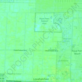
Name: Loxahatchee Groves topographic map, elevation, terrain.
Average elevation: 9 m
Minimum elevation: 4 m
Maximum elevation: 12 m
Other topographic maps
Click on a map to view its topography, its elevation and its terrain.