
Arco topographic map
Click on the map to display elevation.
About this map
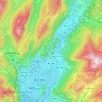
Name: Arco topographic map, elevation, terrain.
Average elevation: 699 m
Minimum elevation: 55 m
Maximum elevation: 2,035 m
Other topographic maps
Click on a map to view its topography, its elevation and its terrain.
Mesiano
Italy > Trentino-Alto Adige/Südtirol > Provincia di Trento > Trento > Povo
Average elevation: 353 m
Cima Palon
Italy > Trentino-Alto Adige/Südtirol > Provincia di Trento
Cima Palon, also called Monte Pasubio, is the highest peak of the Pasubio group of Little Dolomites in Veneto, Italy. It has an elevation of 2,239 metres.
Average elevation: 1,896 m
Canazei
Italy > Trentino-Alto Adige/Südtirol > Provincia di Trento > Canazei > Canazei
Average elevation: 1,823 m
Rolle Pass
Italy > Trentino-Alto Adige/Südtirol > Provincia di Trento > San Martino di Castrozza
Average elevation: 1,996 m