Geolocate

El Chaco topographic map

Click on the map to display elevation.

About this map

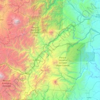
Name: El Chaco topographic map, elevation, terrain.

Location: El Chaco, Napo, Ecuador (-0.52220 -78.19286 0.03430 -77.25717)

Average elevation: 1,978 m

Minimum elevation: 269 m

Maximum elevation: 5,736 m

Other topographic maps

Click on a map to view its topography, its elevation and its terrain.

El Chaco

Ecuador > Napo > Cantón El Chaco > El Chaco

Average elevation: 1,783 m

Gear up for your next adventure:

Tent Footprint - Protect tent floor and increase durability
💧Filtered Water Bottle - Safe drinking water on the go
🧥Thermal Fleece Jacket - Versatile insulation for changing mountain temperatures
🥾Hiking Gaiters - Protect legs and shoes from mud, snow, and debris
🔭Compact Binoculars - Lightweight optics for scouting trails and wildlife

As an Amazon Associate, this site earns from qualifying purchases at no extra cost to you.