Geolocate

Abando topographic map

Click on the map to display elevation.

About this map

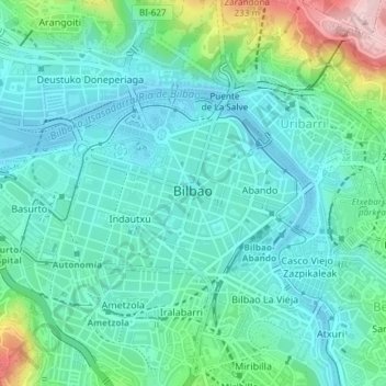
Name: Abando topographic map, elevation, terrain.

Location: Abando, Bilbao, Biscay, Autonomous Community of the Basque Country, Spain (43.25567 -2.95083 43.26990 -2.92369)

Average elevation: 51 m

Minimum elevation: -2 m

Maximum elevation: 296 m

Other topographic maps

Click on a map to view its topography, its elevation and its terrain.

Gear up for your next adventure:

🧭GPS Outdoor Watch - Smart watch for navigation and fitness tracking in nature
🧥Thermal Layer - Insulating layer for cold outdoor conditions
💧Collapsible Water Bottle - Space-saving water bottle for outdoor activities
🧢Hiking Hat - Sun-protective and breathable hats for long treks
💧Hydration Bladder - Hands-free hydration solution for long treks

As an Amazon Associate, this site earns from qualifying purchases at no extra cost to you.