
Make a donation
Gear up for your next adventure:
As an Amazon Associate, this site earns from qualifying purchases at no extra cost to you.
Torres del Paine topographic map
Click on the map to display elevation.
Make a donation
Gear up for your next adventure:
As an Amazon Associate, this site earns from qualifying purchases at no extra cost to you.
About this map
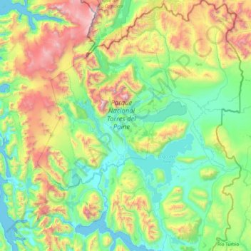
Name: Torres del Paine topographic map, elevation, terrain.
Average elevation: 637 m
Minimum elevation: -3 m
Maximum elevation: 2,745 m
Make a donation
Gear up for your next adventure:
As an Amazon Associate, this site earns from qualifying purchases at no extra cost to you.
Other topographic maps
Click on a map to view its topography, its elevation and its terrain.
Cerro Torre
Chile > Magallanes and Chilean Antarctica Region > Provincia de Última Esperanza > Puerto Natales
Average elevation: 1,916 m
Puerto Natales
Chile > Magallanes and Chilean Antarctica Region > Provincia de Última Esperanza
Average elevation: 141 m
Mirador Cóndor
Chile > Magallanes and Chilean Antarctica Region > Provincia de Última Esperanza > Torres del Paine
Average elevation: 140 m
Cerro Torre
Chile > Magallanes and Chilean Antarctica Region > Provincia de Última Esperanza
Average elevation: 1,916 m
Make a donation
Gear up for your next adventure:
As an Amazon Associate, this site earns from qualifying purchases at no extra cost to you.
Isla Cabrera
Chile > Magallanes and Chilean Antarctica Region > Provincia de Última Esperanza
Average elevation: 80 m
Puerto Natales
Chile > Magallanes and Chilean Antarctica Region > Provincia de Última Esperanza
Average elevation: 141 m
Puerto Natales
Chile > Magallanes and Chilean Antarctica Region > Provincia de Última Esperanza
Average elevation: 141 m
Puerto Natales
Chile > Magallanes and Chilean Antarctica Region > Provincia de Última Esperanza
Average elevation: 141 m
Make a donation
Gear up for your next adventure:
As an Amazon Associate, this site earns from qualifying purchases at no extra cost to you.
Puerto Natales
Chile > Magallanes and Chilean Antarctica Region > Provincia de Última Esperanza
Average elevation: 141 m
Cerro Ballena
Chile > Magallanes and Chilean Antarctica Region > Provincia de Última Esperanza
Average elevation: 400 m
Valle Ascensio
Chile > Magallanes and Chilean Antarctica Region > Provincia de Última Esperanza > Torres del Paine
Average elevation: 1,060 m