
Make a donation
Gear up for your next adventure:
As an Amazon Associate, this site earns from qualifying purchases at no extra cost to you.
Umlazi topographic map
Click on the map to display elevation.
Make a donation
Gear up for your next adventure:
As an Amazon Associate, this site earns from qualifying purchases at no extra cost to you.
Umlazi
Umlazi is situated on a series of undulating hills at an average elevation of 101 metres above sea level between the uMlaza River to the north and the uMbokodweni River to the south. Another river running through Umlazi is the Siphingo River which also runs towards the south of the township.
Make a donation
Gear up for your next adventure:
As an Amazon Associate, this site earns from qualifying purchases at no extra cost to you.
About this map
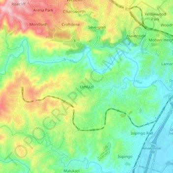
Name: Umlazi topographic map, elevation, terrain.
Average elevation: 100 m
Minimum elevation: 3 m
Maximum elevation: 284 m
Make a donation
Gear up for your next adventure:
As an Amazon Associate, this site earns from qualifying purchases at no extra cost to you.
Other topographic maps
Click on a map to view its topography, its elevation and its terrain.
Palmiet River
South Africa > KwaZulu-Natal > eThekwini Metropolitan Municipality > Pinetown
Average elevation: 308 m
uMngeni River
South Africa > KwaZulu-Natal > eThekwini Metropolitan Municipality
Average elevation: 598 m
Umgeni River
South Africa > KwaZulu-Natal > eThekwini Metropolitan Municipality > Queensburgh
Average elevation: 131 m
Make a donation
Gear up for your next adventure:
As an Amazon Associate, this site earns from qualifying purchases at no extra cost to you.
Pigeon Valley
South Africa > KwaZulu-Natal > eThekwini Metropolitan Municipality > Durban
Average elevation: 69 m
Inanda Dam
South Africa > KwaZulu-Natal > eThekwini Metropolitan Municipality
Average elevation: 222 m
Umbilo River
South Africa > KwaZulu-Natal > eThekwini Metropolitan Municipality > Durban
Average elevation: 56 m
Bluff Nature Reserve
South Africa > KwaZulu-Natal > eThekwini Metropolitan Municipality > Durban
Average elevation: 38 m
Make a donation
Gear up for your next adventure:
As an Amazon Associate, this site earns from qualifying purchases at no extra cost to you.
Umhlanga River
South Africa > KwaZulu-Natal > eThekwini Metropolitan Municipality > Phoenix
Average elevation: 130 m
uMngeni River
South Africa > KwaZulu-Natal > eThekwini Metropolitan Municipality
Average elevation: 598 m
eThekwini Ward 32
South Africa > KwaZulu-Natal > eThekwini Metropolitan Municipality
Average elevation: 25 m
Make a donation
Gear up for your next adventure:
As an Amazon Associate, this site earns from qualifying purchases at no extra cost to you.
Umgeni River
South Africa > KwaZulu-Natal > eThekwini Metropolitan Municipality > Queensburgh
Average elevation: 131 m
Umbilo River
South Africa > KwaZulu-Natal > eThekwini Metropolitan Municipality > Durban
Average elevation: 56 m
Plantations
South Africa > KwaZulu-Natal > eThekwini Metropolitan Municipality > Hillcrest
Average elevation: 631 m
Make a donation
Gear up for your next adventure:
As an Amazon Associate, this site earns from qualifying purchases at no extra cost to you.